About this spot
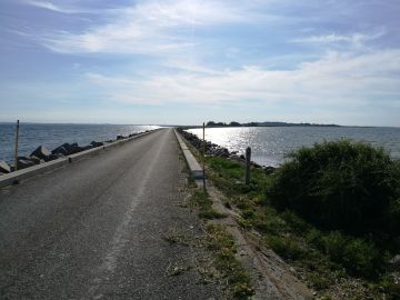
Avernakø is located approximately seven kilometers southeast of Faaborg. Avernakø originally consisted of two independent islands – Avernak to the west and Korshavn to the east. Over time, the islands were connected by a natural land bridge consisting of sand, gravel, and stones from the sea. Such a naturally formed connection is called a drej, a drag, or a tombolo. In 1937, a causeway was built across Drejet. It ensured a stable connection between the islands. You can sail from Faaborg to Avernakø with the ferry, which also sails to Lyø. Avernakø has a total coastline of 19 kilometers with good bathing beaches, fishing spots, and abundant birdlife. In some ponds, there is an opportunity to see and hear the rare klokkefrø. The island has marked hiking and cycling routes, several good accommodation options, and a shelter site. One should not travel in the bird breeding areas at Hovedsø and Revtrille during the period March 1st to June 15th. Significant and rich archaeological finds have been made on Avernakø throughout history. The richest find was made in 1685 in a field in Munke, where six offering bowls with sun symbols made of the purest gold were found. Five of the six gold bowls are now at the National Museum. The sixth bowl was gifted to a French envoy in 1812. It was Avernakø’s contribution to Denmark’s atonement for the fateful alliance with Napoleon. The Maypole, which today functions as the island’s official flagpole, has become a landmark for Avernakø. The tree is a fertility symbol from pagan times. A prayer to the gods for a good harvest in the fields. When the Maypole came to Avernakø is lost to history, but Avernak By and Munke uphold the traditions and adorn the Maypole with beech branches and spring flowers every Whit Saturday.
Facilities
Reviews
No reviews yet — been here? Reviews are coming to CampCompass soon.