About this spot
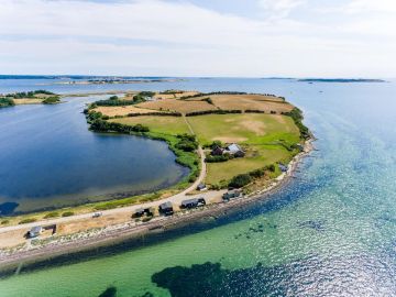
The cliff on the Knolden peninsula (or Knold) is 1 kilometer long and up to 20 meters high. The peninsula was once an independent island, and it is an important geological coastal location in Det Sydfynske Øhav. Knolden is located close to Faaborg and can be easily reached by car, bicycle, or by waterway. Knolden is privately owned, and there is only public access along the beach. To see the cliffs, one must walk a distance along the water from Knoldsvej. Northwest of Knolden lies Drejet with a bathing beach, picturesque bathhouses, and parking facilities. To the northeast lies the former fishing village Dyreborg. A charming little village, sheltered from the westerly wind, with a marina and shopping opportunities. From Dyreborg, one can hike to Dyreborg Skov, which has a shelter and a packed lunch house. The tranquil atmosphere in Dyreborg and the picturesque, whitewashed houses with views over the Øhavet make it easy to understand why Dyreborg and its surroundings have attracted summer guests in droves since the late 1800s. The submerged ice age landscape: Denmark was connected to South England and South Sweden when the last ice age (Weichsel Ice Age) ended approximately 11,700 years ago. Det Sydfynske Øhav and Funen were therefore part of one large contiguous land area with hills, forests, and lakes. As the large ice caps over North America and Northern Scandinavia melted, global sea levels rose. The low-lying land areas south of Funen were flooded, and only the highest parts of the landscape remained above water. These are the 55 islands and islets we know today as Det Sydfynske Øhav.
Facilities
Reviews
No reviews yet — been here? Reviews are coming to CampCompass soon.