About this spot
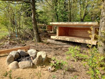
Book: Self-service. The shelter site is located in a 15-hectare hilly forest area with long historical significance. In the middle of the forest lies Resdal Baunehøj, with an elevation of 84 meters above sea level. Previously, the area’s festival grounds served as a gathering point for many events. The old railway track from Sørvad to Ørnhøj is also in the forest and is now used for walks. Additionally, there is a 2.5 km hiking trail and a 4 km MTB track. At the parking lot is the old shooting range, which is still used on certain days in spring. The shelter site’s location is notable for having a very steep slope down to the festival grounds on one side, and on the other, being completely open to fields with a beautiful view to the east and north. Furthermore, it is a very forest-adjacent site, meaning that as much undergrowth as possible has been preserved. There is a grill hut with 2 tables and accompanying benches. The shelter site currently has 3 shelters, each with 4-5 sleeping spaces. Two of the shelters are located at the edge of the forest with a beautiful view to the east. These 2 shelters each have their own fire pit. The 3rd shelter is located in dense forest with a direct view into the trees. The forest shelter does not have its own fire pit. There is a water tap at the parking lot. There is a composting toilet. The site is not suitable for disabled persons. Address: Agerfeldvej 2A, 7550 Sørvad
Facilities
Reviews
No reviews yet — been here? Reviews are coming to CampCompass soon.